Huge Current of Tropical Air Connects Weather Extremes
By CHRISTOPHER DE LOS SANTOS
Reporting Texas
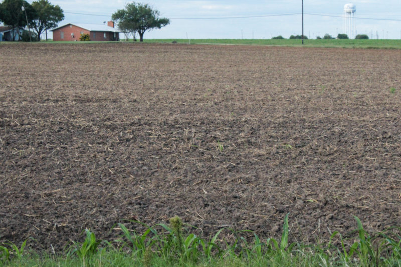
Central Texas farmland in Elgin. Eric Vela/Reporting Texas.
While a snowy Canadian winter is as common as a hot Texas summer, snow rarely falls on the Canadian island of Newfoundland during the last week of June. Yet that happened this year, on the same day the temperature reached 99 in Texas.
It might look like these weather events share no connection at all, since Newfoundland is more than 2,500 miles northeast of Texas. In fact, the same globe-spanning phenomenon caused both extremes.
Scientists call it the Pacific/North American teleconnection effect: Warmer than typical water temperatures in the Pacific tropics create huge movements of air to and from the North and South Poles. In this instance, warm tropical air pushed north over the Pacific.
Some of that warm, moist air crossed Mexico. The rest continued north over the Pacific and, eventually, dislocated cold air over the Arctic. That distorted the jet stream, the current of air that circles the high northern latitudes of the globe.
The warm air crossing Mexico shed its rain in the mountains and brought hot, dry conditions all across Texas and the Great Plains. The dislocated cold Arctic air moved south over Atlantic Canada and eastern Greenland. That’s how it came to snow in Newfoundland on June 26: The jet stream dropped significantly farther south than normal, bringing cold air with it.
In Newfoundland, the snow brought a welcome demonstration of how much cooler – and tourist-friendly – summers there are. In Texas, the heat and lack of rain meant farmers and ranchers had to scramble to save crops and herds.
Huge masses of air warming over the tropics and moving toward the poles actually happens all the time. In the northern hemisphere, over the Pacific it’s called Pacific/North America teleconnection; over the Atlantic, it’s the North Atlantic oscillation.
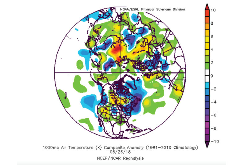
A graphic depicting above and below average temperatures on June 26, 2018. Intensely cold temperatures occurred in Newfoundland while seasonable warmth occurred in Amarillo on the same day. Source: National Oceanic and Atmospheric Administration Physical Sciences Division.
The teleconnection doesn’t usually make news until the warm air pushes over the North Pole and displaces the Arctic air. We see it when summer snows in Atlantic Canada and Greenland accompany warm weather over the rest of North America and over northern Europe, as happened this past June. In winter, the teleconnection can create frigid temperatures in places that usually are milder.
Atmospheric scientists Edward Vizy of the University of Texas at Austin and John Nielsen-Gammon of Texas A&M University both emphasize that while global average temperatures have risen about 1 degree in the last century, effects of that warming on the teleconnection are not yet understood.
The teleconnection has positive negative phases. The positive phase is what brought warm temperatures to Texas, the U.K. and Norway this summer, along with snows in Newfoundland .
Vizy said the positive phase teleconnection usually begins with warmer surface temperatures in the eastern Pacific, often called El Nino. Heating on the surface of the eastern Pacific pushes warmer air up the west coast of the U. S. and Canada into Alaska.
When the positive phase teleconnection peaks, warmer air masses push into the Arctic, dislocating the polar air masses south to Atlantic Canada, the U.S. eastern seaboard or elsewhere over Europe or Asia. When this combination of effects occurred in the U.S. during winter of 2007-2008, weather forecasters called it a Polar Vortex. For example, In March 2008, Cleveland, Ohio, received a record 30.4 inches of snow, and in Erie, Penn., it snowed a record 33.9 inches.
The negative phase teleconnection is often associated with cooler temperatures in the waters of the eastern Pacific, known as La Nina. These cooler surface temperatures lead to cooler air masses over the Pacific, which in turn allow warmer Atlantic air masses to push up the eastern seaboard into Atlantic Canada.
According to Neilsen-Gammon, large-scale jet stream fluctuations are not that unusual, either. When Nielsen-Gammon spoke to Reporting Texas on September 7, weather in the Northern Hemisphere included unseasonable warmth over the Bering Sea and off the coast of Alaska, coupled with unseasonable cold in Siberia. London was 6 degrees colder than normal, and Moscow was 6 degrees warmer.
Back on June 26, near Amarillo, rancher and planter Jesse Weiners, who had just planted his cotton crop a few weeks before, faced a high temperature of 99 and extremely dry conditions.
Weiners had already sold his beef cattle earlier than he wanted to. The continued lack of rain combined with the third-warmest June on record ruined both his corn crop and his cotton crop. After selling his own herd early, Weiners lead a successful effort by the Texas Farm Bureau to get the U.S. Department of Agriculture to open up reserve grazing lands to remaining cattle
Results of the snows in Newfoundland proved more favorable.
Jackie Cumby of the St. John’s Board of Trade in Newfoundland, said that by the first of July the snow had melted, and by mid-July, temperatures were returning to normal. The tourist season got off to a slow start due to the snow, Cumby said, but a cooler June allowed her to promote Newfoundland to tourists as a haven from sweltering heat.